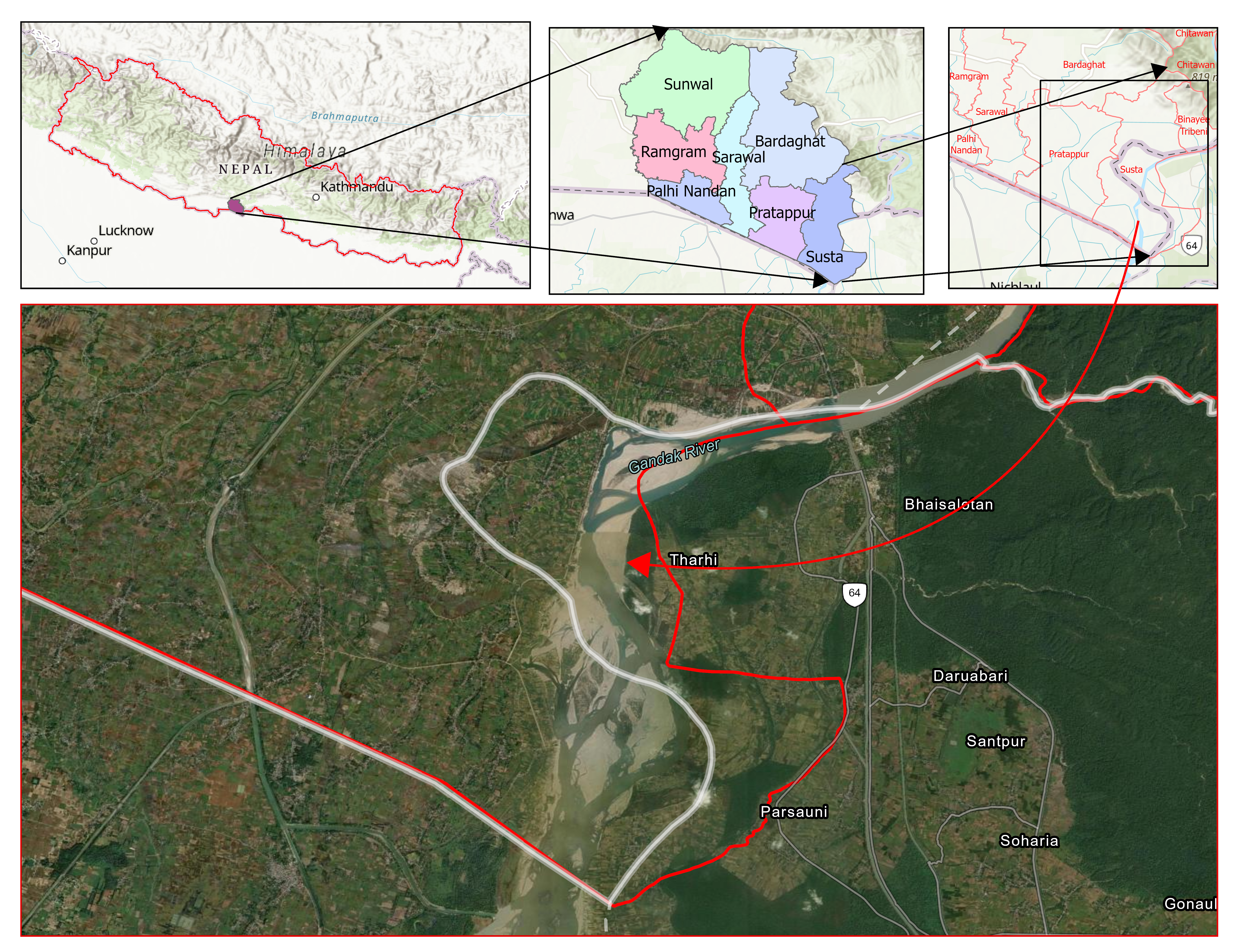
To understand the complexity of the shifting border, we must first examine the broader geographical context of the Susta region. Below is our definitive study area map.
Region where direct encroachment of Nepalese Land by India Occurs due to informal settlement of Indian labour
This is one of the most sensitive border regions between Nepal and India, where informal settlement by Indian nationals on land claimed by Nepal, combined with the shifting course of the Narayani (Gandak) River, has intensified the boundary dispute. Nepal maintains that the area is its sovereign territory and seeks the return of the land, while India considers the area disputed pending a bilateral resolution.
Interactive topographical view centered on Susta coordinates (27.52°N, 84.02°E).
The treaty that drew the line
Nepal's border with India runs roughly 1,800–1,880 km across its southern, eastern, and western flanks[1], almost all of it fixed by asingle document: the Treaty of Sugauli, signed in March 1816 between the Kingdom of Nepal and the British East India Company after the Anglo-Nepalese War[2,3]. In the plains that concern Susta, the treaty took the Narayani River, called the Gandak once it enters India, as the international boundary, assigning the right (western) bank to Nepal and the left (eastern) bank to British India[1,4].
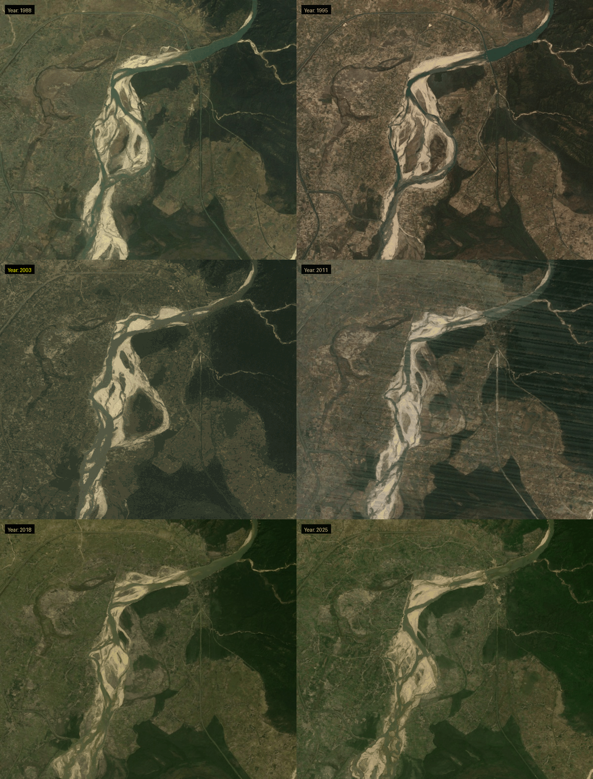
At the time the treaty was signed, the village of Susta lay onthe Nepali side of the river[1,5]. Two centuries of monsoon floods later, that is no longer where the river runs.
Historians note that for roughly 200 years after Sugauli, almost no border disputes surfaced between Nepal and India; friction only became frequent after India militarized Kalapani following the 1962 Sino-Indian war, and separately, as the Narayani's (Gandak) course kept shifting through the 20th century [6].
In the plains that concern Susta, the treaty took the Narayani River called the Gandak once it enters India as the international boundary, assigning the right (western) bank to Nepal and the left (eastern) bank to British India. At the time the treaty was signed, the village of Susta lay on the Nepali side of the river.
Why a river makes a bad border
Some borders are drawn by mountains. Others are drawn by rivers that refuse to stand still.
Roughly 600 km of the Nepal–India border runs along rivers: the Mechi in the east, the Mahakali in the west, and the Narayani at Susta in between[7,8]. Large alluvial rivers naturally erode their banks, deposit sediment, and migrate across the floodplain over time.
Nepal holds to the fixed-boundary principle the border is the river's course as it ran in 1816, regardless of where the channel sits today. India's practical position has been that the land east of the river's current course falls under its administration.[9,10]
Survey record
The missing 24 kilometers of pillars
British surveyors erected 72 iron ("Junge") pillars from Rupandehi to Nawalparasi's Sagardhinha in 1817–18.[10]
A roughly 24 km stretch of the Narayani between Triveni Ghat and the area south of Susta has no pillars ever planted on either bank.[10]
That stretch remains without official markers today; locals rely on informal landmarks at one point, a single silk-cotton tree served as the de facto boundary marker.[12]
Along the Nepal–India border, the Department of Survey has identified 8,554–8,555 boundary pillars. As of 2025, approximately 1,325 pillars were reported missing and 1,956 were partially or fully damaged, meaning that nearly 40% of the boundary markers require repair, replacement, or verification.[13] The deteriorating condition of these boundary pillars complicates border demarcation and contributes to recurring territorial disputes, including the long-standing Susta issue.
The Narayani in motion
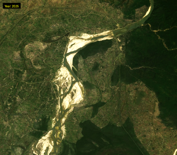
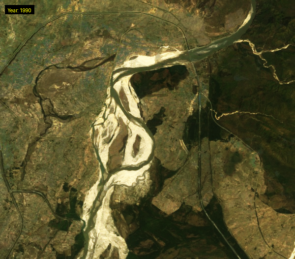
Slide to compare how the river channel has shifted over 35 years. By some accounts, the river has eroded roughly 13,000–14,500 hectares of what Nepal considers its territory on the western bank.
1990 satellite view2025 satellite view
How the land moved: a flood history
Former Department of Survey Director General Buddhi Narayan Shrestha, one of Nepal's foremost border experts, documented the Narayani (Gandak) River's major channel shifts during five significant flood events, illustrating how repeated river migration has progressively altered the Nepal–India boundary in the Susta region.[10,14]:
1845
River suddenly shifted west, cutting into Nepali territory.
July 1954
Major flood; river shifted further west.
1972
Another significant course change was reported.
1980
Massive flood: Susta's village panchayat was displaced to Triveni. The river alone cut roughly 100 hectares that year.
1989
Further erosion recorded.
According to Buddhi Narayan Shrestha, the Narayani (Gandak) River's repeated course shifts have resulted in the loss of approximately 13,000–14,500 hectares of land that Nepal considers part of its territory on the river's western (Nepali) bank, while more recent estimates place the affected area at around 14,860 hectares.[1,10,14,15] A 2024 assessment by the Nepal Army and local administration estimates Susta's historical area at approximately 40,980 hectares, of which around 19,980 hectares are officially recognized as disputed. The report further states that about 14,500 hectares are under Indian occupation, while Nepal currently exercises practical control over only 7,000 hectares.[16] Although the exact figures vary among sources and survey periods, they consistently indicate that a substantial portion of Susta's historically recognized territory now lies beyond Nepal's effective administrative control.
Settlement & citizenship
Resettlement, displacement, and a citizenship gap
1965
King Mahendra resettled around 400 families, including many former Nepali security personnel, in Susta specifically to reinforce Nepal's presence on the border.[12]
1977
That settlement was displaced after the Narayani changed course again, turning much of the area into riverbed; the village panchayat structure was abolished and Susta was reduced to a single ward. India is reported to have begun encroaching from the south of the vacated area soon after.[12,17]
2009
Around 1,000 Indian farmers, reportedly backed by Indian security personnel, entered Susta, destroyed roughly 10 hectares of Nepali-planted sugarcane, and were accused of intimidating local families — one of the incidents that prompted the founding of the "Save Susta Campaign."[18]
2024
Rising Nepal Daily reported Susta's population at roughly 3,133 people in 265 households, but only about 295 residents had obtained Nepali citizenship, leaving an estimated 1,600 people eligible but undocumented — unable even to get a SIM card or work legally in either country.[16]
2024
A long-awaited 1.4 km suspension bridge over the Narayani connecting Susta to the rest of Nepal was reported roughly 90% complete, with locals hopeful it would ease decades of isolation.[16]
2026
Susta's Ward 5 today counts roughly 350–417 households and 3,200–3,600 residents, depending on the source and survey, hemmed in by the Narayani on three sides and Indian territory on the fourth — which local officials say makes emergency response and rescue extremely difficult during floods.[19,20]
~3,133
Residents recorded in Susta, 2024 (265 households)
~295
Residents holding Nepali citizenship, 2024
~1,600
Eligible residents left undocumented, 2024
~90%
Completion of the 1.4 km suspension bridge, 2024
On the ground · 1990s–2026
Confrontations on the ground
After the Gandak Barrage at Bhainsalotan/Valmikinagar was built under the 1959 Nepal–India Gandak Agreement, Indian laborers who had worked on the project settled in the area, and Indian security (the Sashastra Seema Bal, SSB) established a permanent presence in Susta.[21,22] Shrestha's account also describes the encroached area, at one point, becoming a haven for cross-border timber smugglers and dacoits, including one notorious figure named Sucha Singh.[10]
2018
A dispute resurfaced after India attempted to expand a road through disputed land, a decade after both sides had agreed not to build anything roads, plantings in the contested strip.[23]
May–June 2026
Nepal began building two riverbank embankments (100 m and 132 m) in Susta Rural Municipality-5 to control erosion; SSB personnel objected, and construction on the 132 m section was suspended pending "higher level" coordination between the two governments.[24]
June 2026
Indian SSB personnel briefly crossed into Nepali territory near Tharu Tol while trying to bypass a waterlogged section of the border; Susta residents confronted them, and they withdrew after a brief standoff.[12]
Locals say incidents of this kind have become more frequent since Nepal's own prime minister's parliamentary remarks about encroachment put the border back in the news.[24]
Diplomacy · 1981–2025
The diplomatic machinery, and why it stalls
1981
Nepal and India formed a Joint Technical Committee (JTC) to scientifically re-survey and map the entire border.[25,26]
2007–2009
The JTC completed 182 GPS-based strip maps covering roughly 97–98% of the border explicitly excluding Susta and Kalapani, the two areas where the two sides could not agree. Nepal's Parliament advised the government not to sign off on the strip maps until Susta and Kalapani were resolved, and Nepal declined to ratify them in January 2009.[25,26,27]
2014
During PM Narendra Modi's visit to Nepal, the two countries agreed to create the Boundary Working Group (BWG), again handling pillar construction/repair and no-man's-land clearance again excluding Susta and Kalapani, which were instead assigned to talks between the two countries' foreign secretaries. Those foreign-secretary-level talks on Susta and Kalapani specifically have still never been held.[25,27,28]
2016–2018
An Eminent Persons Group reviewed the full bilateral relationship and finalized a joint report in 2018 which, as of the most recent reporting, still has not been formally accepted by both governments.[27]
2019
The 6th BWG meeting was held in Dehradun, India (Aug 28–30), with both sides agreeing to finish remaining boundary work by 2022.[13,29]
2020–2024
COVID-19, and then a separate map dispute (Nepal's 2020 constitutional map showing Kalapani, Lipulekh and Limpiyadhura), froze BWG meetings for six years. Nepal sent multiple diplomatic notes pressing India to resume talks. The most recent Nepal–India Joint Commission at foreign-minister level, held in Kathmandu in January 2024, also called for reconvening the BWG.[13,29]
July 2025
The 7th BWG meeting finally resumed in New Delhi after a six-year gap. Both sides agreed to a new three-year deadline, completing all technical boundary work, other than Susta and Kalapani, by 2027 or 2028.[13,29]
Nepal's own former ambassador Nilambar Acharya has estimated that roughly 97% of the entire Nepal–India border has effectively been agreed and demarcated; the unresolved 3% is concentrated almost entirely in Kalapani, Lipulekh, Limpiyadhura, and Susta.[9]
2026
2026: the dispute erupts again
March 27, 2026
Balendra "Balen" Shah the 36-year-old former Kathmandu mayor and rapper-turned-politician whose Rastriya Swatantra Party swept the March 2026 election was sworn in as Nepal's prime minister.[5]
May 31, 2026
Answering questions in the House of Representatives, PM Shah said both countries had encroached on each other's land in multiple places, adding that both sides needed to sit down together. The remark triggered immediate controversy in both countries.[3,4,29]
"Not only has India encroached on Nepal's land, but Nepal has also encroached on India's land in multiple places." - PM Balendra Shah, House of Representatives, May 31, 2026[3,4,29]
Hours later, May 31
The Ministry of Foreign Affairs clarified that Shah's comment referred to encroachment in the no-man's-land (Dasgaja) strip and everyday cross-border land use, not a territorial concession, noting that riverine stretches demarcated under the fixed-boundary principle inevitably leave some citizens farming or residing on the "wrong" side.[29]
May–June 2026
Indian SSB personnel objected to Nepal's embankment construction in Susta; work on the 132-metre section was suspended pending government-to-government coordination, while the 100-metre section continued.[24]
June 12, 2026
SSB personnel briefly crossed into Nepali territory near Tharu Tol and were confronted by residents before withdrawing.[12]
July 1, 2026
Foreign Minister Shishir Khanal told Nepal's National Assembly that Susta and Kalapani "are integral parts of Nepal," that demarcation there remains incomplete, and that the government holds "historical evidence, maps, and other supporting documents" to substantiate the claim, while confirming embankment work was paused pending coordination with India.[30,31]
Two positions, side by side
Nepal's positionIndia's position / administration
Legal basis
The 1816 Sugauli Treaty fixed the Gandak/Narayani as the boundary; that historical river line should still define the border — the "fixed boundary principle."
Susta is administered as part of West Champaran district, Bihar, and Indian citizens live, farm, and hold land-use claims there.
Territorial & residency claim
Susta sat on Nepal's side when the treaty was signed, and its residents are — and always have been — Nepali citizens.
India's practical approach has favored the boundary following the river's present course, and India has not endorsed Nepal's 2007 JTC strip maps for this sector.
Path forward
Nepal wants a comprehensive, jointly ratified boundary protocol covering Susta once and for all, rather than indefinite deferral.
India has generally preferred to leave Susta's status unresolved rather than actively press a formal legal claim, maintaining the practical status quo on the ground.
Status · July 2026
Where things stand
Updated · 1 July 2026
The 7th Boundary Working Group (BWG) round in 2025 set a target of finishing all other boundary sections by around 2027–2028 but by design, that timeline still excludes Susta and Kalapani, which require a separate, higher-level political decision that hasn't materialized in over a decade. On July 1, 2026, Nepal's Foreign Minister reaffirmed in Parliament that Susta and Kalapani remain Nepali territory.
Sourcing
References
This story map was built from a live web search pass conducted in this conversation, July 2026. Every factual claim above is tied to one or more of the sources below; where figures differ between sources (e.g., total hectares affected), both are presented rather than reconciled into a single "true" number, since even Nepali government sources vary across years and surveys.